Description
Our work on forests and climate arises in part from the current controversy regarding whether forests cool or warm the global climate. It is clear that the carbon held in the forest biomass reduces the carbon dioxide in the atmosphere, reducing the greenhouse effect. On the other hand, forests have a lower albedo than most other land surface types, thus absorbing a higher fraction of the sun’s radiation. The relative importance of these two physical processes should be determined to guide policy decisions on afforestation and deforestation.
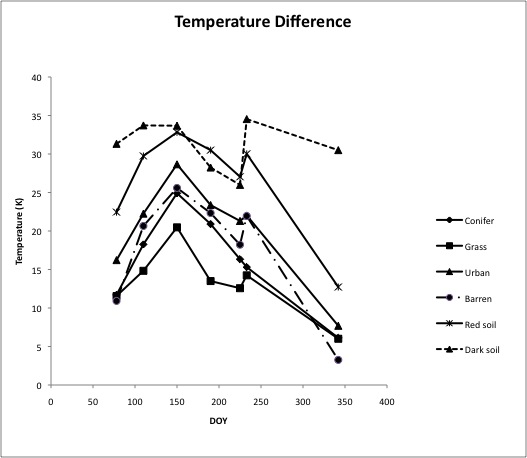
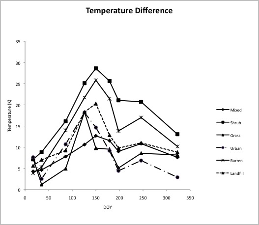
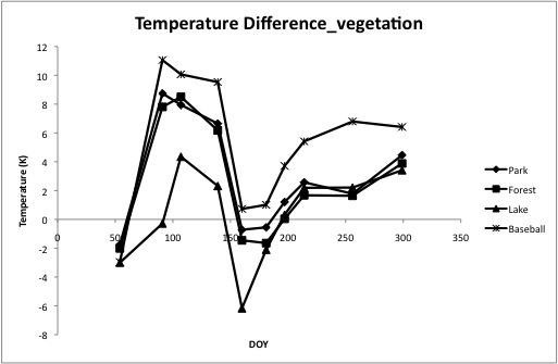
To contribute to this debate, we are studying the surface temperatures for five land surface types: Deciduous forest, coniferous forest, grass, urban and water. Shown below are some preliminary results from Connecticut. Using Landsat images, we determine the “skin” radiative temperature for each surface and reference it to the local air temperature. The results show how this temperature difference varies from Spring to late Fall. We also determine the albedo of each surface to aid on heat budget calculations.
Preliminary Results
Presentations
- June 16th: Forest Paradox
- July 14th: Connecticut Survey by Ronald Smith
- July 14th: Comparing characteristics among different land covers (NDVI, Albedo, and Temperature) by Ziyan Chu
- July 21st: Updated presentation_5 Replicas by Ziyan Chu
- July 28th: ASTER images analysis by Ziyan Chu
- June 30: Comparing parameters among Landsat 5 and Landsat 7 by Ziyan Chu
- Aug 11th: Preliminary Results Presentation, Land cover analysis in Minnesota
- Oct 14th: Seasonal changes in exchange coefficient by Ronald Smith
- Nov 11th: Atmospheric correction by Ziyan Chu
- Dec 2nd: Updated results in CT and AZ by Ziyan Chu (spatial distribution patterns)
- Jan 20: Spatial Pattern in Exchange Coefficience by Ziyan Chu
Useful Links
Temperature Difference in Arizona

Temperature Difference in South California

Temperature Difference of Vegetation in Minnesota
